
c.1881 O'Connell Town Estate map and James Mitchell family history
- fuji321
- Dec 30, 2022
- 2 min read
Updated: Apr 28, 2025

Portion 210 and 211 (119 acres) of the Redcliffe Agricultural Reserve was first purchased by James Mitchell on the 19th July 1871.
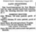
Brisbane Courier 2nd August 1871:
"Homestead Selections:
Charles Cutts - 20 acres pastoral, Redcliffe.
Conditional Purchases:
James Mitchell - 240 3/4 acres second class pastoral, Redcliffe"
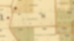
1878 map:

1883 Humpybong map - with the first few houses indicated by the red dots:
James Mitchell was born in Perth Scotland on 8th August 1820.
He married Jessie Fenwick on 13th November 1850 in Perth, Scotland.

The family emigrated to Australia on the "City of Brisbane" departing 21st February 1862 from Gravesend, Scotland. Arriving in Moreton Bay on 26th June 1862 with their 2 sons David Henry Fenwick Mitchell (1856-1939) and Marshall Dunleavy Mitchell (1858–1939)
James passed away on 25th March 1890 in Nambour


The land was sold in the early 1880's to William Bligh Henry O'Connell.
William was educated in England at Rugby School. He undertook bush experience at Baramba Station. Other positions included aide de camp to his uncle Sir Maurice Charles O'Connell and a clerk in the Bank of New South Wales in Bundaberg. He was an Inspector to Pacific Islanders and assistant immigration agent and an estimator in a mercantile firm in Bundaberg. He was MLA for Musgrave, and from 1899 -1903, Secretary to Public Lands in Queensland. We was also a friend of Redcliffe identity Colonial Felix Bernard Theodore Wilhelm Koch. (They were both made lieutenants M Company, Q.V.1., Bundaberg in 1880)
The Telegraph Saturday 27th May 1882 Page 5:
"WANTED KNOWN.— The O'Connell Town, Humpy Bong, is now surveyed into 277 Business and Residence Sites, fronting main coach road, a few minutes walk from beach, post office, church, and school. Prices from £3. Terms 10s. deposit, and 10s. per month ; no interest, free transfers and lithographs. Apply, J. H. Henzell & Co., Albert street, Brisbane"

A land sale map created in 1881 showing a development called O'Connell Town Estate, with proposed streets and a sketch showing local landmarks.

Portion 210 went on to be subdivided and went on to become Kippa Ring industrial park and residential streets west of Ashmole Rd and north of Anzac Ave, including:Beach St, High St, Dalton St, Oleander St, Sparkes St, Northcott St and Bingle St.

"O'Connell Town , Humpybong Parish Of Redcliffe, Sections 1-13 of Portion 210, containing 227 Superior Marine Villa and Business Sites."
Local Sketch contains: Post Office, Main Coach Road to Redcliffe Point and Scarborough, Edwardstown, Reserve for water, Portwood Estate, proposed Jetty site deepwater, Oyster Rocks, Redcliffe Point, Wharf Reserve, Redcliffe Estate, State School, Humpybong water holes, OLearys Hotel(opened in 1881) and Church. 
The streets shown on the map were not built until over 80 years later, when the Kippa Ring industrial estate was developed in the 1960'/70's
Another c.1881 O'Connell Town Estate map:

A 1956 and 2022 aerial showing the location of O'Connell Town:

Maps from the Pictorial History Of Redcliffe Book 1824-1949:
All maps are also available to purchase at 5 Alexander St Scarborough. ( 9 to 3 pm Monday to Friday. Saturdays 9 to 1pm) and free delivery in the Moreton Bay region.